


Conserving America’s Wetlands 2007:
Three Years of Progress
Implementing the President’s Goal
Executive Summary
| 2005-06 Reports* |
This Report |
|
| Acres Restored or Created | 588,000 | 300,000 |
| Acres Improved | 541,000 | 488,000 |
| Acres Protected | 601,000 | 251,000 |
| Total Acres | 1,730,000 | 1,039,000 |
| *Agency accomplishments as adjusted by actual results; these totals do not reflect net totals, as they do not account for wetland acres lost or damaged. | ||
On Earth Day 2004, President Bush celebrated the opportunity to move beyond the Federal policy of “no net loss” of wetlands and called for a new commitment to attain an overall increase in the quality and quantity of wetlands in America.
As President Bush said in April 2004, “The old policy of wetlands was to limit the loss of wetlands. Today I’m going to announce a new policy and a new goal for our country: Instead of just limiting our losses, we will expand the wetlands of America.”
President Bush described his goal for expanding wetlands acreage as both creating new wetlands and improving the quality of existing wetlands. The President also required that we protect existing, high-quality wetlands. His goal is to achieve at least one million acres in each of these separate categories between Earth Day 2004 and 2009. This goal reflects agency performance in restoring, improving, and protecting wetland acres. The goal does not reflect a net acreage total (i.e., the goal does not reflect loss of wetlands).
After three years of progress toward the President’s fiveyear goal, the team of six Federal departments working with multiple states, communities, tribes, and private landowners is on track to meet or exceed this goal.
Since this goal was set, 2,769,000 acres of wetlands have been restored or created, improved, or protected.
This report also highlights anticipated progress between Earth Day 2007 and 2008, during which time the Bush Administration expects an additional one million wetland acres to be restored or created, improved, or protected.
The President’s focus on wetlands has prompted these accomplishments, as well as improvements in cooperation and understanding among the many Federal departments, states, communities, tribes, and landowners that care for and manage wetlands. The Federal Government team includes the Environmental Protection Agency and the Departments of the Interior, Agriculture, Commerce, Transportation, and the Army.
Many agencies of government contribute to the continuing goal of “no net loss” by ensuring mitigation for wetlands that are developed for other uses. Even though mitigation for wetlands replaces more wetland acres than are lost, these numbers are not included in the three categories reported here. The report describes these and other programs that contribute to maintaining the Nation’s wetlands base.
This report chronicles the major contributions of Federal agencies, working together and in partnership with others, to achieve the President’s wetlands goal of three million acres by 2009.
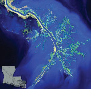
Landscape Change Processes on the Deltaic Gulf Coast |
|||
The hurricanes of 2005 have brought a sense of urgency to Gulf Coast restoration. The Mississippi River is a lifeline for transporting goods and services, and its coastal delta is the gateway. The Port of South Louisiana handles the most tonnage of any port in the Nation. This economic engine coexists with unique ecosystems that support important fisheries and habitats for migratory birds. Although recent hurricanes have highlighted its vulnerability, the Gulf Coast was already experiencing the impacts of human modification to the Mississippi River system. Enormous challenges are posed by the need to restore the northern coast of the Gulf of Mexico to an ecologically functioning system, while also maintaining the navigation of the Mississippi and Atchafalaya Rivers, flood control structures, and hurricane levees and other storm protection devices. Meeting these challenges will require new data and more cross-disciplinary methods in support of goals that transcend the interest of any single stakeholder group. Land-Building, Then and Now The Mississippi River Deltaic Plain is a succession of river deltas formed over the past 10,000 years by the sediment eroded from the continent into the Mississippi River and its tributaries during rainfalls, storms, and floods. When the river reached shallow coastal waters, its velocity slowed and suspended sediments dropped out, creating deltaic land on the Continental Shelf. Following the most efficient route to the Gulf, the river changed its course every 1,000 to 1,500 years, creating new deltas. Plants took hold and stabilized the new land, and erosional forces of winds, waves, and surge periodically eroded the new landscapes, scoured adjacent waterbottoms, and transported sediments along the coast. Today, this natural cycle of marsh-building in the Delta has been interrupted. Hundreds of locks and dams along the Mississippi River and its tributaries preclude sediments from reaching the Delta and surrounding wetlands. Soil conservation and dams reduce the sediment load to the river from storms. Levees and river bank stabilization reduce the natural erosion of the stream bank, and levees prevent natural flooding and land-building as the river passes through the Deltaic Plain. |
While these land-building processes are being interrupted, both natural and human-caused destructive processes persist, such as erosion, saltwater intrusion, the invasive nutria that eats vegetation, subsidence (sinking), and increasing sea level rise. In 2005, Hurricanes Katrina and Rita transformed 217 square miles of Louisiana’s coastal lands to open water, 119 miles of which lay in the Deltaic Plain. This amount of loss in one year represents almost half of the land loss scientists predicted would take place over a 50-year period. The Scientific Challenge Many proposals are being developed to achieve a sustainable coast, including retaining Mississippi River sediments in coastal wetlands to emulate the natural geologic and hydrologic processes. These processes, which once built the wetlands, are now critically needed to protect human communities. To provide sound science for decision making, the U.S. Geological Survey works with Federal, state, university, and other partners to monitor wetlands recovery; research impacts related to sedimentation, elevation change, plant community structure, and physical and chemical wetland attributes; create landscape predictive models; use radar to study impacts to and recovery of wildlife populations and habitats; and monitor restoration success and evaluate restoration alternatives. |
||