


- Afghanistan
- Africa
- Budget Management
- Defense
- Economy
- Education
- Energy
- Environment
- Global Diplomacy
- Health Care
- Homeland Security
- Immigration
- International Trade
- Iraq
- Judicial Nominations
- Middle East
- National Security
- Veterans
- President's Cabinet
- USA Freedom Corps
- Faith-Based & Community Initiatives
- Office of Management and Budget
- National Security Council
- USA.gov
Chapter Three: Hurricane Katrina - Pre-Landfall
Hurricane Katrina is now designated a category five hurricane. We cannot stress enough the danger this hurricane poses to Gulf Coast communities. I urge all citizens to put their own safety and the safety of their families first by moving to safe ground.
-- President George W. Bush, August 28, 20051
Hurricane Season Forecast
Hurricane Season:
The official Atlantic hurricane season takes place each year between June 1 and November 30, with peak hurricane activity generally occurring between mid-August and mid-October.
In an average year, ten tropical storms develop in the Gulf of Mexico, Caribbean Sea, or Atlantic Ocean; six of these storms become hurricanes. In a typical three-year span, five hurricanes hit the United States mainland; two are designated major (Category 3 – 5) hurricanes. The southeastern United States is the region most vulnerable to a hurricane strike. The States most likely to be hit by a major hurricane are Florida, Texas, and Louisiana.
On May 16, 2005, Brigadier General David L. Johnson (ret.), Director of the National Oceanic & Atmospheric Administration (NOAA), National Weather Service (NWS), released the 2005 Atlantic hurricane outlook to kick off National Hurricane Preparedness Week.In its report, NOAA assessed a 70 percent chance of an above-average hurricane season, predicting twelve to fifteen Atlantic tropical storms, with seven to nine becoming hurricanes and three to five of those becoming major hurricanes (equivalent to Categories 3, 4, and 5 on the Saffir-Simpson scale). 2 NOAA also noted that the previous year had been “extremely active,” with fifteen Atlantic tropical storms, including nine that developed into hurricanes.3 That same day, Max Mayfield, Director of the National Hurricane Center (NHC), cautioned, "[l]ast year’s hurricane season provided a reminder that planning and preparation for a hurricane do make a difference. Residents in hurricane vulnerable areas who had a plan, and took individual responsibility for acting on those plans, faired [sic] far better than those who did not."4
The first two months of the 2005 hurricane season confirmed NOAA’s predictions, with a record seven Atlantic tropical storms developing in June and July.5 Two of these storms developed into major hurricanes, including Hurricane Dennis, "an unusually strong July major hurricane that left a trail of destruction from the Caribbean Sea to the northern coast of the Gulf of Mexico."6 Dennis prompted mandatory evacuations in the lower Florida Keys and major disaster declarations in Alabama, Florida, and Mississippi.7 Louisiana Governor Blanco declared a state of emergency.8 While Cuba ultimately received the worst of the damage inflicted by Dennis, the NHC still estimated U.S. damages in excess of two billion dollars.9
| Category | Winds |
| 1 | 74 - 95 mph |
| 2 | 96 - 110 mph |
| 3 | 111 - 130 mph |
| 4 | 131 - 155 mph |
| 5 | Greater than 155 mph |
On August 2, 2005, NOAA released an updated 2005 Atlantic hurricane season outlook that projected the formation of an additional eleven to fourteen tropical storms, with seven to nine becoming hurricanes, including three to five major hurricanes. Based on the developments in June and July, NOAA revised its assessment to a “95 to 100 percent” chance of an above-normal 2005 Atlantic Hurricane season.It reported that “the atmospheric and oceanic conditions favoring hurricane formation that were predicted in May are now in place. These conditions, combined with the high levels of activity already seen, make an above-normal season nearly certain.”Moreover, while there already had been “considerable early season activity,” NOAA emphasized that the next three months constituted the peak of hurricane season.10 NHC Director Mayfield explained, “Knowing precisely where a hurricane will strike and at what intensity cannot be determined even a few days in advance.”He urged that “residents and government agencies of coastal and near-coastal regions should embrace hurricane preparedness efforts and should be ready well before a tropical storm or hurricane watch is posted.”11 With four more months remaining in hurricane season, the NOAA outlook proved an ominous forecast.
Katrina's Beginnings
August 23, 2005
On Tuesday, August 23, the NWS reported Tropical Depression Twelve had formed over the Bahamas from the remnants of Tropical Depression Ten.12 The NHC released the first in what would be a series of sixty-one advisories over the next seven days reporting on and tracking the development of the storm.13
The Federal government began monitoring the storm as a potential hurricane shortly after the NWS announced Tropical Depression Twelve had formed. Federal department and agency Emergency Operation Centers (EOC)—bases used to coordinate and direct response activity—began to closely monitor NWS bulletins and incorporate them into their own updates and situation reports.
The U.S. Northern Command (USNORTHCOM), the military command charged with defending the U.S. homeland and providing military support to civil authorities, also began monitoring the Tropical Depression at its Operations Center in Colorado Springs, Colorado, on August 23.14
August 24, 2005
On Wednesday, August 24, the Tropical Depression strengthened into a Tropical Storm and was given the name Katrina, the eleventh named storm of the 2005 hurricane season.15 The Federal Emergency Management Agency (FEMA) activated its Hurricane Liaison Team (HLT), consisting of FEMA, NWS, and State and local officials.The HLT deploys to the National Hurricane Center to assist in the coordination of advisories with Federal, State, and local emergency management agencies, providing forecast updates and technical advice.16 FEMA Region IX was notified to prepare for possible back-up should Mississippi or Georgia be affected. USNORTHCOM also issued a Warning Order for supporting commands to prepare for requests for Department of Defense (DOD) assets should the need arise.17
August 25, 2005
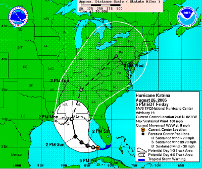
Katrina continued to gain strength throughout the day on Thursday, as it approached the southeastern coast of Florida.18 At 3:30 pm edt, Katrina was upgraded to a Category 1 hurricane and forecast to make landfall in Florida.
Meanwhile, advisories issued by the NWS Tropical Prediction Center (TPC) and the NHC predicted Katrina would turn toward the Alabama-Florida panhandle area after it crossed Florida and entered the Gulf of Mexico.19 At 6:30pm edt, Hurricane Katrina made landfall in south Florida near the Miami-Dade and Broward County line, with sustained winds of up to 80 miles per hour and dropping as much as 14-16 inches of rain in some regions.20 The Florida landfall resulted in more than a dozen deaths,21 over 1.4 million power outages,22 and pockets of severe flooding. Damage costs in south Florida amounted to just under $2 billion,23 with an estimated $400 million in agricultural losses.24
Gulf Coast States and localities began hurricane preparations on Thursday, August 25, even as the storm approached its first landfall in Florida, by activating their emergency response elements, issuing emergency declarations, pre-positioning response assets, and planning for evacuations and sheltering. Because NWS advisories predicted Katrina would enter the Gulf and make landfall on the Northern Gulf Coast area, Alabama and Mississippi activated their Emergency Operations Centers (EOCs) to coordinate information and their State’s resources for emergency response operations.25
In preparation for Florida landfall, FEMA delivered 100 truckloads of ice to staging areas in Georgia, and thirty-five truckloads of food and seventy trucks of water to Palmetto, Georgia. Also, anticipating a potential second Gulf Coast landfall, FEMA pre-staged over 400 truckloads of ice, more than 500 truckloads of water, and nearly 200 truckloads of food at logistics centers in Alabama, Louisiana, Georgia , Texas, and South Carolina.26 This was the beginning of the pre-staging efforts that increased to the largest pre-positioning of Federal assets in history by the time Hurricane Katrina made its second landfall on August 29, 2005.27 At this time, FEMA placed Rapid Needs Assessment and Emergency Response Teams – Advance Elements (ERT-As) on alert.An ERT-A is “the portion of the Emergency Response Team (ERT) that is the first group deployed to the field to respond to a disaster incident.”28 FEMA also conducted their first video teleconference, a call held each day at noon from August 25 until well after landfall. These video teleconferences helped synchronize Federal, State, and local responders and were a means of defining and coordinating assistance and support needs.29
Numerous private sector entities took action as well. Norfolk Southern Railroad, for example, recognized the potential impact of the loss of certain key bridges and pre-staged repair barges in order to be able to move in quickly to make repairs after the hurricane made landfall.The Cargill Corporation, an agricultural products and services company, also pre-positioned freighters offshore so that it could continue shipping grain internationally immediately after landfall.
Katrina Enters The Gulf Of Mexico
August 26, 2005
Katrina briefly weakened to a Tropical Storm as it passed over Florida in the early hours of Friday, August 26, but by 5:00am edt, the NHC reported that the storm had once again strengthened to a Category 1 hurricane.30 The hurricane continued moving further west, intensifying over the warm waters of the Gulf, rather than north toward the Alabama-Florida panhandle area as NWS had originally predicted.31 This westward direction enabled the storm to strengthen first to a Category 1 and then intensify to a Category 2 hurricane over the course of the day.
In the afternoon of August 26, the NHC released a track forecasting the eye of Hurricane Katrina would pass just east of New Orleans on Monday, August 29.32 This forecast and all subsequent NHC forecasts projected Hurricane Katrina would make its second landfall as a Category 4 or 5 storm along the Gulf Coast, in the Mississippi-Louisiana region.33 The Center also forecasted that the accompanying coastal storm surge would cause flooding fifteen to twenty feet above normal tide levels where the eye of the hurricane would make landfall.34 National Weather Service Director Johnson later testified before Congress that “forecasts of where Katrina would go were more accurate than usual, with all of the forecast tracks during the last forty-eight hours lining up almost directly on top of the actual track.”35 The last NHC Hurricane Katrina forecast on Friday, August 26, as the storm intensified in the Gulf of Mexico, gave Federal, State, local, and private sector officials, in hindsight, approximately fifty-six hours advance notice that the hurricane would make landfall near the City of New Orleans.36
Preparations took on a greater urgency on Friday, August 26, due to Hurricane Katrina’s continuing intensification and west-southwest track from Florida into the Gulf of Mexico. Louisiana Governor Kathleen Blanco and Mississippi Governor Haley Barbour declared states of emergency for their respective States.37 Gulf Coast States and localities expanded their EOC staffing and operations schedules in anticipation of Hurricane Katrina.38 The Alabama, Louisiana, and Mississippi State EOCs soon were activated to their highest levels.39
State agencies began putting their response plans into action.The Louisiana State Police notified personnel assigned to the Traffic Control Center that they should report to the State EOC the following day, at 6:00 am cdt, to prepare for emergency response operations.40 The Louisiana National Guard began mobilizing 2,000 personnel while the Joint Forces headquarters-Louisiana National Guard activated its Joint Operations Center (JOC) at Jackson Barracks in New Orleans to coordinate their emergency response operations.41 Governor Barbour issued an Executive Order that directed Major General Harold Cross, Adjutant General of the Mississippi National Guard, to prepare to use the Mississippi National Guard for disaster relief operations.42 The Mississippi National Guard alerted military police and engineers, activated 750 personnel, and activated its EOC in Jackson.43
Worst Case Scenario
A catastrophic hurricane striking Southeast Louisiana has been considered a worst-case scenario that the region and many experts had known and feared for years.Much of Southeast Louisiana is at or below sea level, and experience had shown Gulf Coast hurricanes to be deadly.At the turn of the 20th Century, an unnamed Category 4 hurricane made landfall on September 8, 1900, in Galveston, Texas.With storm surges higher than fifteen feet and winds stronger than 130 mph, over 8,000 people perished - making it the deadliest disaster in American history.44 Sixty-five years later, on September 9, 1965, Hurricane Betsy made its second landfall near Grand Isle, Louisiana, as a strong Category 3 storm. As an omen of things to come, Hurricane Betsy’s storm surge and high winds hit Lake Pontchartrain just north of New Orleans, overtopping levees and flooding the city. Breaching the Florida Avenue levee, flood waters consumed the Lower 9th Ward of New Orleans, drowning many in their attics as they tried to escape.In total, seventy-five people were killed and over 160,000 homes were flooded.45 Only four years later, Hurricane Camille, a Category 5 hurricane, struck the mouth of the Mississippi River on the night of August 17, 1969.Storm surges measuring over twenty-five feet, combined with winds estimated close to 200 mph, caused an estimated 335 deaths, destroyed or damaged 22,008 homes, and injured thousands in Louisiana, Mississippi, and Virginia.46 In the decades that followed, experts attempted to model the likely impact of future hurricanes to improve protection in the Gulf Coast region.47 In 2000, the U.S. Army Corps of Engineers’ (USACE) modeled the effects of a slow moving Category 4 or any Category 5 hurricane on the region.48 According to the Corps, New Orleans would be inundated by over twenty feet of water if such a hurricane took a “critical path” towards the city.49 A weaker, slow moving hurricane can be as dangerous as a more powerful, faster moving storm because it can generate as much or more flooding by dropping more rainfall.50 Vice Admiral Conrad C. Lautenbacher, Jr., Undersecretary of Commerce for Oceans and Atmosphere, stated in 2002 that the overtopping of the levees and subsequent flooding of the city could occur during slow moving Category 3, 4 or 5 storms.51 Recognizing that current Federal, State, and local disaster response capabilities overall needed to be enhanced to better address possible effects of catastrophic disasters, FEMA provided funding for a Southeast Louisiana Catastrophic Hurricane Planning Project, which brought together responders and decision makers from all levels of government and the American Red Cross to identify, analyze, and address the overwhelming operational complexities that would be involved in responding to a catastrophic hurricane striking southeast Louisiana.52
Planning workshops using a hypothetical catastrophic hurricane scenario (Hurricane Pam) to frame the discussions were used to identify and qualify the scale of requirements needed to build a plan for responding to a catastrophic hurricane.The initial planning group meeting was held between July 16 and July 23 in 2004 and included as many as 300 Federal, State, and local emergency response officials.53 The results of this exercise revealed to the Louisiana Office of Homeland Security and Emergency Preparedness (LOHSEP) and FEMA the shortfalls in existing plans and were to be used to inform future development of State and Federal plans to address this potential catastrophe.At the first session, LOHSEP and Federal representatives identified a list of planning topics as the most urgent or complex topics needing discussion, including pre-landfall issues, search and rescue, and medical care, as well as mass sheltering and housing. Subsequent after-action review workshops did not reconvene until late July 2005, mere weeks before Hurricane Katrina made landfall. Although they failed to generate a comprehensive, integrated, and actionable plan in time for Hurricane Katrina, these workshops did have some positive impact.To quote one official: “the workshops and planning process—knowledge of inter-jurisdictional relationships and capabilities, identification of issues, and rudimentary concepts for handling the consequences—have been beneficial to all involved in the hurricane response.”54
FEMA headquarters in Washington, DC, conducted the daily video teleconference from their National Response Coordination Center (NRCC) to exchange information and reconcile response activities among the FEMA Regions, the NHC, liaisons from various Federal agencies and departments responsible for disaster support, representatives from the States projected to be affected by the storm, and States monitoring and providing mutual aid to support their neighbors.55
August 27, 2005
Hurricane Katrina strengthened to a Category 3 storm before dawn on Saturday, August 27, and nearly doubled in size over the course of the day; tropical storm-force winds extended 85 miles from the storm’s center at 2:00am edt and 160 miles from the storm’s center at 9:00pm cdt.56 National Hurricane Center forecasts warned the storm could continue to intensify and was expected to become a Category 4 storm,57 pushing a powerful storm surge ahead of its path.58 The Center issued updated hurricane watches and warnings throughout Saturday, with a hurricane watch eventually extending across the North Central Gulf Coast from Intra-coastal City, Louisiana, to the Florida-Alabama border.59
Despite hurricane watches and warnings throughout the day, it appeared many people along the Gulf Coast either remained unaware or unconcerned about the storm that would soon ravage their communities.For instance, according to Governor Blanco, State Representative Cedric Richmond called the Louisiana Governor on Saturday after visiting a ballpark where “approximately 700 people were present, and [he] learned that some people had not paid attention to the weekend news and did not realize the severity of the hurricane aiming at New Orleans.”She recalled that he worried “many may have thought the hurricane was still targeting the Florida panhandle, as reported by the National Hurricane Center up until late Friday afternoon.”60
As the storm strengthened, Louisiana and Mississippi State officials took steps to begin the evacuation of areas threatened by Hurricane Katrina throughout Friday evening and into Saturday morning. Early Saturday morning, Louisiana State Police Superintendent Colonel Henry Whitehorn and Louisiana Department of Transportation and Development Secretary Johnny Bradberry recommended to Governor Blanco that she implement the State’s contra-flow plan. Governor Blanco and her staff had determined that a major evacuation of coastal Louisiana and New Orleans would be required.She and Governor Barbour discussed implementing their respective contra-flow plans on Saturday for interstate highways and other major roadways; the plans would reverse the flow of traffic on inbound lanes to facilitate the evacuation of the New Orleans metropolitan area.61 Shortly thereafter, Louisiana Department of Transportation and Development officials informed Mississippi Department of Transportation officials that contra-flow in Louisiana would begin later that afternoon.62 Louisiana State agencies also began implementing Phase I of the Louisiana Emergency Evacuation Plan, which included public communications, staging of assets, and other activities.63 Louisiana and Mississippi implemented contra-flow plans on major highways at 4:00 pm cdt.64 State law enforcement officers were deployed along the routes and in communities to assist evacuation operations. Louisiana established a Traffic Control Center (TCC) within the State EOC and began monitoring traffic volume and rate of flow.65 Traffic increased throughout the day.By 7:00 pm cdt, traffic had begun to back up at the Louisiana-Texas border.66 Louisiana and Mississippi had jointly revised their respective evacuation plans after encountering problems during Hurricane Ivan in 2004.67
Still, State and local officials knew that tens of thousands of Gulf Coast residents either could not or would not evacuate. A large number of residents who did not own a vehicle depended on relatives, neighbors, charitable organizations, or public transportation to evacuate; New Orleans hurricane plans estimated that over 100,000 residents did not own an automobile.68 Evacuation also presented particular risks to the special needs population, which includes older adults and individuals with a disability. Individual and institutional caregivers faced the difficult choice between the dangers of evacuation and attempting to ride out the hurricane.69
In an effort to reach as many citizens as possible, Governor Blanco and her staff contacted clergy throughout Saturday night and early Sunday morning to ask them to urge their parishioners to evacuate immediately.70 In addition, Louisiana churches had implemented “Operation Brother’s Keeper,” a program developed to help evacuate those who lacked transportation, but only four congregations were participating in the pilot program when Hurricane Katrina made landfall.71
Local governments across the northern Gulf Coast issued evacuation orders throughout Saturday. Voluntary evacuations for areas in Louisiana outside the levee protection district began in the morning.Lafourche, Plaquemines, St. Charles, and parts of St. Tammany Parishes ordered mandatory evacuations for their citizens during the day.72 Mandatory evacuation orders were also issued for parts of Jefferson Parish.In New Orleans, Mayor Ray Nagin hosted a press conference that afternoon, during which he recommended evacuations of Algiers, the Lower Ninth Ward, and low-lying areas of the City.73 Later, at 5:00 pm cdt, he formally called for voluntary evacuations of the City.74 He also declared a state of emergency for New Orleans, which advised residents to undertake several precautionary measures such as stocking up on bottled water, batteries, and non-perishable food.75 In a joint press conference with Governor Blanco, Nagin warned residents, saying “this is not a test.This is the real deal.”By late afternoon, Mississippi’s three vulnerable coastal counties—Hancock, Harrison, and Jackson—had also begun urging residents to evacuate, especially those living in low-lying areas and mobile homes.76
Many Gulf Coast residents had become so accustomed to hurricanes and tropical storms that they refused to evacuate despite the warnings.77 As Hurricane Katrina approached Louisiana, Governor Blanco was concerned “that many people would play a familiar game of ‘hurricane roulette’—tempting fate and staying home in a gamble that this storm would be no worse than the last one they weathered in their home.”78
Hurricane Katrina’s impending landfall required massive shelter operations in order to temporarily house thousands of people fleeing the Gulf Coast.On Saturday, August 27, shelters began opening throughout the region.In Mississippi, the American Red Cross opened shelters in schools and churches.79 It also established an information center to direct evacuees to shelters in the Jackson area.80 By 4:00 pm cdt, Louisiana’s Office of Emergency Preparedness reported that four special needs shelters were open in Alexandria, Baton Rouge, Bossier City and Monroe, with four more scheduled to open at 8:00 pm cdt that evening.81 Mayor Nagin also announced that the New Orleans Superdome would be open to City residents with special needs.82 A special needs shelter “is intended for individuals who have no other resources and who need assistance that cannot be guaranteed in a regular shelter, i.e. medication that requires refrigeration, oxygen equipment, etc.”However, it is not intended for patients who need substantial or constant medical care.83 Texas officials also opened shelters on Saturday, including a 1,000 person capacity shelter at the Ford Center in Jefferson County.84
Louisiana and Mississippi State agencies deployed personnel and pre-positioned resources in the final two days before Hurricane Katrina’s second landfall.The Mississippi Emergency Management Agency also deployed six area coordinators to six Gulf Coast counties to serve as liaisons with their EOCs.85 Mississippi’s State Emergency Response Team (ERT) deployed to Camp Shelby while National Guard emergency rescue assets were deployed to three coastal counties.86 The Louisiana National Guard deployed liaison officers to the thirteen southernmost parishes projected to suffer the greatest impact from the storm.87 Alabama officials began pre-positioning supplies at staging areas and other locations throughout the State.88 Alabama National Guard troops were positioned in Mobile and Baldwin Counties in preparation for landfall, and Governor Bob Riley of Alabama, after being informed that Louisiana and Mississippi would suffer the brunt of the storm, offered Governors Blanco and Barbour whatever assistance his State could provide.89 The Texas Governor’s Division of Emergency Management deployed one Regional Liaison Officer to Baton Rouge “to assist, coordinate, and monitor any requests for assistance that may develop as evacuations begin.”90
As State and local governments were preparing their response and initiating evacuations, the Federal government was continuing preparations to support State and local responders.On the morning of August 27, forty-eight hours before Hurricane Katrina’s second landfall, FEMA headquarters commenced Level 1 operations, requiring full staffing on a round-the-clock, seven-days-a-week basis.91 FEMA was now at its highest alert.FEMA’s regional headquarters for Regions IV (Atlanta, Georgia ) and VI (Denton, Texas) went to Level 1 activation at Noon edt and 11:00 am cdt respectively.92 At this point, all fifteen National Response Plan (NRP) Emergency Support Functions (ESFs) had been activated as well.93
With the regional and national headquarters at full alert, FEMA held another daily video teleconference at 12:00 pm edt.“FEMA Region VI announced that its Mobile Emergency Response Support (MERS) detachment was en route to Camp Beauregard, Louisiana, to provide communications and operational and logistical support.It also announced that it had requested the deployment of the Denver MERS unit to Region VI headquarters in Denton to serve as a backup.”94 In addition, Region VI had staged at Camp Beauregard 270,000 liters of water, 680,000 pounds of ice, 15,120 tarps, and 328,320 Meals Ready to Eat (MRE).95 By 5:00 pm edt, the quantity of water stored at Camp Beauregard had doubled to 540,000 liters.96 More commodities were pre-staged elsewhere in Region VI.The FEMA Logistics Representative reported that 102 trailers were “uploaded with water and MREs” at the FEMA Logistics Center in Ft. Worth, Texas.97 Also at Noon that day, the ERT-N Blue Team was activated and deployed to Baton Rouge.98 The ERT-A Blue Team is one of the Nation’s three standing ERT-N teams.One of three teams—code-named Red, White, and Blue—is on call every month.99 The ERT-N teams are the scalable principal inter-agency units that staff the JFO “for large-scale, high-impact events.”
FEMA was working to pre-stage supplies in Region IV, too.At 1:15 pm edt, FEMA issued its first Mission Assignment to USNORTHCOM “to provide NAS Meridian [Mississippi] as a FEMA operational Staging Base for pre-staging of FEMA supplies prior to landfall.”100 USNORTHCOM granted this request later that afternoon, releasing an Execute Order making Naval Air Station Meridian available to FEMA.101
Additionally, FEMA began activating the National Disaster Medical System (NDMS), Disaster Medical Assistance Teams (DMATs), and Urban Search and Rescue (US&R) teams102 The DMATs are mobile self-contained medical teams with equipment and medical professionals trained and certified to provide emergency medical care to disaster victims. These teams are comprised of professionals from around the country organized and deployed by FEMA to support disaster response activities.The Urban Search and Rescue teams are similarly structured, but comprised of emergency responders, firefighters, and law enforcement personnel from around the country.
That evening, President Bush signed a Federal emergency declaration for the State of Louisiana, following a request from Governor Blanco earlier that day. President Bush issued additional emergency declarations for Mississippi and Alabama the following day, after requests from the governors of those States.103 These declarations authorized Federal expenditures to assist State and local governments by providing resources and making other preparations to save lives and property from Hurricane Katrina’s imminent impact.104 These decisions were particularly important as they allowed delivery of pre-deployed Federal assistance.The issuance of a Presidential emergency declaration before landfall is extremely rare, and indicative of the recognition that Katrina had the potential to be particularly devastating. Since 1990, only one such incident, Hurricane Floyd in 1999, resulted in declarations before landfall.105 By declaring emergencies in these three States, the President directed the Federal government to provide its full assistance to the area to save lives and property from Hurricane Katrina’s imminent impact.106
On the evening of August 27, William Lokey, the ERT-N team leader, arrived in Baton Rouge, Louisiana, and was appointed Federal Coordinating Officer (FCO).As the senior Federal official in charge of supporting the State of Louisiana, he immediately began coordinating efforts with the Louisiana Office of Homeland Security and Emergency Preparedness.107
Hurricane Katrina’s growing intensity on Saturday led NHC Director Mayfield to make personal calls to State and local officials in the region that evening to emphasize the threat posed by the storm.He warned Jefferson Parish officials that this could be the “big one.”That evening, Director Mayfield briefed Governor Blanco, Governor Barbour, Mayor Nagin, and Alabama Emergency Management Agency Chief of Operations Bill Filter about Hurricane Katrina’s magnitude and the potential storm impacts.108 Director Mayfield testified before Congress that he had only made such a call to warn a governor once before in his thirty-six year career.109 Mayfield stated that “I just wanted to be able to go to sleep that night knowing that I did all I could do.”110
At FEMA headquarters, the FEMA Director shared Mayfield’s concern. Closing the noon video teleconference with his FEMA regional staff and the State EOCs, Michael Brown urged them to be vigilant, saying, “I know I’m preaching to the choir on this one, but I’ve learned over the past four and a half, five years, to go with my gut on a lot of things, and I’ve got to tell you my gut hurts with this one.It hurts...So we need to take this one very, very seriously...I want you guys to lean forward as far as possible...Why is this important? Because I worry about the people in New Orleans, Louisiana, and Mississippi right now, and they’re going to need our help...”111
August 28, 2005
Hurricane Katrina developed from a Category 4 to a Category 5 storm over a six-hour period on Sunday, August 28.112 The storm had become “not only extremely intense but also exceptionally large.”113 The National Weather Service office in Slidell, Louisiana, issued a detailed, urgent warning of Hurricane Katrina’s impending devastating impact on the Gulf Coast. The warning stated, “The majority of industrial buildings will become non-functional...High-rise office and apartment buildings will sway dangerously - a few to the point of total collapse.All windows will blow out. Airborne debris will be widespread - and may include heavy items such as household appliances and even light vehicles...Persons - pets - and livestock exposed to the winds will face certain death if struck.”114 The NHC issued advisories that warned the levees in New Orleans could be overtopped by Lake Pontchartrain and that significant destruction would likely be experienced far away from the hurricane’s center.115 The warning continued, “[m]ost of the area will be uninhabitable for weeks...Perhaps longer...Power outages will last for weeks...Water shortages will make human suffering incredible by modern standards.”116
Prior to Hurricane Katrina’s landfall, State and local officials did not use the Emergency Alert System (EAS) in Louisiana, Mississippi, or Alabama. However, the National Hurricane Center (NHC) disseminated warnings and forecasts via NOAA Radio and the internet, operating in conjunction with the EAS.117 Initially, these reports were issued every six hours; however, as the storm neared landfall they were updated with increasing frequency.118 In accordance with NOAA policy, local weather offices took over responsibility for these broadcasts shortly after Hurricane Katrina made landfall.At this time, Weather Service offices like the one in Slidell, Louisiana, began to transmit real-time hazard information using both NOAA Radio and the EAS. These reports were distributed to all area media outlets as well as local emergency management personnel.When the severity of the storm finally forced the Slidell weather office offline, operations were successfully transferred to weather centers in Mobile and Baton Rouge.
Taking heed of the continual warnings, most citizens evacuated, others showed up at a “shelter of last resort” and some hunkered down in their homes and would soon be struggling to survive the destructive forces of Katrina.For the region and its residents, Hurricane Katrina would bring devastation and the incredible human suffering that the NHC had predicted.
By early morning on Sunday, three State Liaison Officers (SLOs) had been deployed to Alabama, Florida, and Mississippi.119 The U.S. Coast Guard, in preparation for anticipated operations, placed Disaster Assistance Response Teams (DARTs) on standby for deployment to Southeast Louisiana and evacuated its District 8 New Orleans Command Center to Integrated Support Command, Saint Louis, Missouri.120
Also early that morning, President Bush called Governor Blanco to urge that mandatory evacuation orders be issued for New Orleans.121 After receiving a call from President Bush, Governor Blanco and Mayor Nagin held a joint press conference during which the Mayor ordered a mandatory evacuation of New Orleans.122 Later that day, the President also participated in FEMA’s daily video teleconference with DHS headquarters, FEMA headquarters, FEMA’s regional offices, the National Hurricane Center, and representatives from Alabama, Florida, Georgia , Louisiana, Mississippi, Tennessee, Texas, and West Virginia.The President personally encouraged State and local officials to take all precautions and get word out to their citizens; he offered the full support and resources of the Federal government.123 The President “received regular briefings, had countless conversations with Federal, State, and local officials, and took extraordinary steps prior to landfall.”124 The Louisiana EOC reported that evacuations were going well, that it had no unmet needs, and that FEMA was “leaning forward” as far as possible.The Mississippi EOC similarly reported that “FEMA has been great” and that, after a slow start, evacuations were going well.125 Despite State assurances, the FEMA Director told all those on the call to be prepared for the impending requests for emergency aid from the States, expressed concern about the evacuation progress and the Superdome as a shelter of last resort, and echoed his previous day’s comments about the need to remain vigilant.126 Secretary Chertoff inquired into DOD’s level of engagement with FEMA, to ensure coordination of DOD support should it become necessary, and was assured by Director Brown that DOD was fully engaged.127 Following the video teleconference on Sunday, FEMA Director Michael Brown deployed from Washington to Baton Rouge.128
After the video teleconference, Homeland Security Secretary Michael Chertoff spoke with the participating State governors to ensure that their needs were being met.He later explained, “[m]y concern then was to talk off-line to the governors, to make sure the governors weren’t going to tell me something privately that maybe they didn’t want to share publicly, and they seemed satisfied at that point with the help they were getting.”129
The President also issued a public statement, saying “[w]e cannot stress enough the danger this hurricane poses to Gulf Coast communities. I urge all citizens to put their own safety and the safety of their families first by moving to safe ground. Please listen carefully to instructions provided by State and local officials.”130
By afternoon on August 28, States and localities across the Gulf Coast had just hours before tropical storm-force winds would curtail their contra-flow and other pre-landfall preparations. State and local officials in Alabama and Mississippi issued evacuation orders for low-lying areas vulnerable to Hurricane Katrina’s storm surge and encouraged people in other areas to evacuate as well.131
The Gulf Coast States’ planning and the contra-flow operations facilitated the safe evacuation of hundreds of thousands of people on Sunday, August 28.132 However, by the late afternoon, Hurricane Katrina began to affect evacuations even though landfall remained over twelve hours away. Increasing winds around New Orleans’ Louis Armstrong International Airport caused air carriers to begin reevaluating their plans and canceling flights.The last passenger flight departed at 4:30 pm cdt and the airport was officially closed at 6:43 pm cdt.133 Contra-flow operations throughout the region ceased at 5:00 pm cdt due to high winds from Hurricane Katrina. Louisiana and Mississippi State officials continued to encourage people to evacuate even after contra-flow operations ceased. Governor Blanco later estimated that 1.2 million people, 92 percent of the affected population, evacuated prior to Hurricane Katrina’s second landfall.134 Still, tens of thousands, many of them the region’s most vulnerable, remained in areas most threatened by the approaching hurricane.
By Sunday evening, shelter operations that had begun the previous day were in full force. Thousands of people displaced by Katrina were in shelters across the region. Federal, State, and local governments worked with the American Red Cross and other non-profit organizations to establish at least 114 shelters for over 28,000 people.135 Texas had opened or placed on standby thirty-one shelters with room for 7,275 evacuees and established “shelter welcome centers” along I-20 and I-10 “to provide shelter information to evacuees.”136 The City of New Orleans, which had previously provided the Superdome as a shelter only for the special needs population, now opened it as a “shelter of last resort” for the general population.137 Additional supplies were brought in to support the growing Superdome population despite increasingly worsening conditions.138 It was estimated that there were 10,000 - 12,000 people at the Superdome by midnight, including 300 - 500 special needs evacuees.139
As Hurricane Katrina drew nearer, the requests for Federal assistance increased.The day before landfall, FEMA received numerous requests for resources from Alabama, Louisiana, and Mississippi.140 Some last minute Louisiana requests were not met due to deteriorating weather conditions.For example, at noon on August 28, Louisiana requested 180,000 liters of water and 109,440 MREs for the Superdome. However, FEMA was only able to supply 90,000 liters of water and 43,776 MREs before the storm struck or high winds forced other trucks to turn back before they could reach the stadium.141 Officials at all levels were unsure of who and how many people would come to the Dome and were modifying their special needs and commodities requests throughout the day.The American Red Cross determined the Superdome did not meet their safety criteria and refused to put their staff in harm’s way, choosing rather to deliver any necessary aid to the Dome as soon as the storm had passed.142
During a press conference, in response to a question about the Superdome, the Mayor asserted that “the Superdome can probably accommodate 50,000, 60,000, 70,000 people.”He advised that anyone seeking shelter there should “come with enough food, [non] perishable items to last for three to five days.Come with blankets, with pillows.No weapons, no alcohol, no drugs.”143
The Louisiana National Guard also pre-positioned some supplies at the Superdome. Approximately 10,000 MREs and over 13,000 bottles of water were brought in on Saturday, when the stadium was opened as a special needs shelter for evacuees with heightened care requirements.144 In addition to stocking the Superdome with food and water, the Louisiana National Guard sent additional personnel to the Superdome throughout the day on Sunday, August 28.The National Guard’s Special Reaction Team, a unit “highly trained in Law Enforcement missions,” arrived at 7:00am cdt with forty-six members.145 The team “began conducting Law and Order/Area Security missions.”146 More National Guard forces got to the Dome in the early afternoon.By 3:00 pm cdt, the 527th Ready Reaction Forces had arrived in the Superdome with 220 personnel, and had as their principal mission crowd control.147 The 225th Engineer Group joined that evening with 220 soldiers “to assist with security operations.”Another 100 personnel from the 159th Fighter Wing came to help out with security.148 Medical personnel arrived at the Superdome from the Louisiana National Guard contingent as well.“Five physicians, four nurses, six NCOs and twenty medics” deployed to the Superdome on August 28.149 In all, “the total medical complement at the Superdome totaled 71 medical personnel.”150
In addition to the mandatory evacuation order, Mayor Nagin announced Sunday that he had authorized New Orleans Police Department members and other City officials to commandeer private property for evacuation and shelter purposes, if necessary. Mayor Nagin said, “[t]he storm surge most likely will topple our levee system.So we are preparing to deal with that also.”151 The Louisiana State Police reported that one of its 800 MHz communications towers had been rendered inoperable and some troopers had been forced to seek shelter at hospitals.152 Additionally, by August 28, fifteen of Louisiana’s sixty-four parishes had issued mandatory, recommended, or precautionary evacuation orders.153
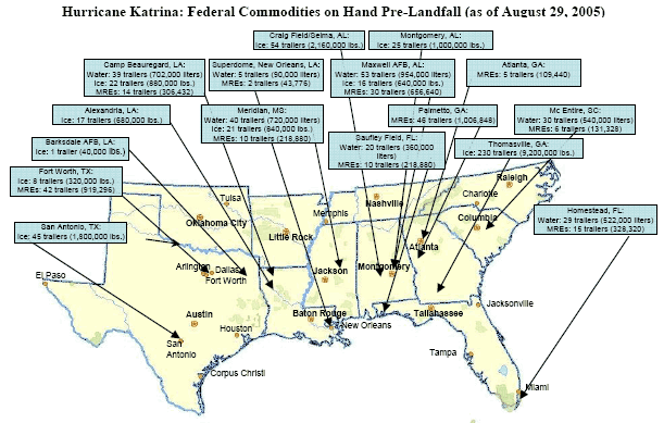
Pre-deployed assets were placed throughout the region to encircle the forecasted impact area.The amount of space required to house the large volumes of commodities and people required large industrial and military staging areas—often filling entire runways with hundreds of trailers—accessible to heavy equipment and aircraft.The staging areas were dispersed outside the projected path of the storm to avoid destruction of critical commodities and to maximize the ability to deploy to affected areas in the wake of the hurricane.On Sunday, FEMA opened a Federal logistics mobilization center at Barksdale Air Force Base in Louisiana,154 quickly placing a MERS team there with a mobile communication command vehicle.155 MERS assets were also deployed on-site into Mississippi, Florida, Georgia , and Texas, and other parts of Louisiana to support response operations.”156 Other Federally deployed teams in the region included seven Urban Search and Rescue Task Forces and thirty-three National Disaster Medical System teams, including Disaster Medical Assistance Teams, medical Strike Teams, a National Medical Response Team, Disaster Mortuary Operational Response Teams, and Veterinary Medical Assistance Teams.As of pre-landfall on the next day, a total of 43,776 MREs and 90,000 liters of water had been staged at the Superdome.Throughout the region there were pre-staged over 3.7 million liters of water, 4.6 million pounds of ice - with 13 million additional pounds of ice in cold storage ready to be deployed - and over 1.86 million MREs. Another 2.1 million MREs were positioned in Logistics Centers outside the region ready to be distributed (see Federal Commodities Map).157
The Storm Approaches
As the sun set on Sunday, August 28, rain began to fall and the Gulf Coast had already started to feel Hurricane Katrina’s effects.158 The storm’s high winds and hail forced public safety agencies across the Gulf Coast to curtail their operations. Traffic remained heavy on some highways as people tried to escape the storm in the final hours before second landfall.In shelters, hospitals, nursing homes, and residences across the Gulf Coast, people held their breath, hoping that Hurricane Katrina’s impact would not be catastrophic. Federal, State, and local governments were poised to continue emergency activities as soon as Hurricane Katrina had passed. State and local governments, supported by the Federal government and FEMA, had carried out unprecedented preparations in comparison to those made for previous, “average” hurricanes.But Hurricane Katrina was not average, as would soon become vividly clear—it was a fierce hurricane with high wind speeds and a near-record storm surge that was heading directly toward a densely-populated urban area, much of which lay below sea level—six feet below on average across the city.159 In less than twenty-four hours, Hurricane Katrina would change the region, its people, and the Nation.
