


Conserving America’s Wetlands 2008:
Four Years of Partnering Resulted in
Accomplishing the President's Goal
Perspective
Federal agencies have accomplished the acreage targets of the President’s five-year goal in four years—a full year ahead of schedule. Each of the agencies developed creative solutions, with particular emphasis on public–private partnerships and cooperative conservation. These partnerships involve federal, state, and local governments; corporations; a wide range of nongovernmental conservation organizations; and, in many cases, individuals.
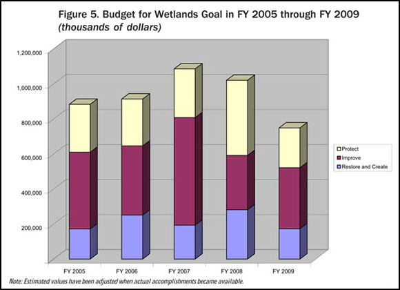
The ability to meet in four years the President’s targets to restore or create, improve, or protect one million acres in each of these three categories was supported by over $3.9 billion in agency funding (Figure 5).
Cooperative conservation made important contributions to accomplishing the President’s wetlands goal. Voluntary programs that work directly with individual landowners, including Partners for Fish and Wildlife (FWS) and the Wetlands Reserve and Conservation Reserve programs (USDA), continue to be key to restoring, improving, and protecting wetlands.
Large-scale ecosystem restoration partnerships between federal and state entities in south Florida and coastal Louisiana continue to help address wetlands issues. Holistic approaches are employed to restore these critical habitats. Integrating wetlands restoration into the larger recovery plans for the Gulf Coast in the aftermath of Katrina, Rita, and other hurricanes makes good ecological sense, but it also makes good economic sense. Conserving and restoring wetlands is not only critical for recovery efforts along the Gulf Coast, but is also an important part of our national approach to community planning and development, as more and more of the population lives in coastal counties. Integrating coastal restoration with hurricane protection plans for the future has been legislatively mandated in Louisiana and embraced by its citizens as essential to the survival of Louisiana’s economy and unique culture. Coastal wetlands will become even more important as buffers to ameliorate erosion and reduce the height of storm surges as we experience the impacts of climate change.
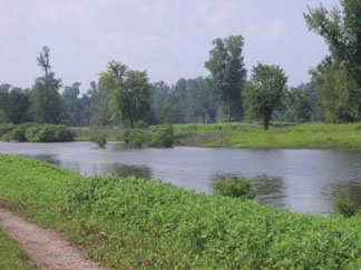 |
This restored oxbow lake in the Mississippi River watershed in Iowa can hold
floodwaters to reduce flooding downriver, settle out sediments that would otherwise smother fish-spawning beds, and filter out pollutants to provide
clean water and reduce the dead zone in the Gulf of Mexico. (USDA) |
The Energy Policy Act of 2005, through its Coastal Impact Assistance Program (CIAP) section 384, may provide $250 million in each fiscal year from 2007 through 2010 to eligible coastal states and their coastal political subdivisions for projects and activities to: protect, restore, or conserve coastal areas, including wetlands; mitigate damage to natural habitats; administer the program; implemental federally approved marine, coastal, or comprehensive conservation management plans; and mitigate the impact of Outer Continental Shelf activities through funding of onshore infrastructure projectsand public service needs. A maximum of 23 percent of the funds can be spent on two of those uses—administration of the program and mitigation of Outer Continental Shelf activities. In November 2007, DOI’s Minerals Management Service approved Louisiana’s CIAP State Plan, making Louisiana the first eligible coastal state to receive federal approval under this program. Louisiana’s Plan is dominated by wetland restoration and conservation projects and programs, such as creating marshes with dredged material, restoring Mississippi River inflows into adjacent wetlands, protecting and restoring barrier and interior shorelines that help protect adjacent wetlands, and conserving coastal forests.
Increased federal attention to wetlands efforts has heightened public awareness of the importance of wetlands and their role in sustaining a resilient coast. The devastating hurricanes of 2005 have served to increase the sense of urgency among the American public for conserving, restoring, and creating coastal wetlands. An informed public working in partnership with federal, state, tribal, and local agencies provides an opportunity to ensure wetlands are conserved for future generations.
These cooperative conservation and stewardship efforts depend on accurate, timely, and reliable data that provide a common working map of where restoration efforts have been realized, are in progress, or need to be initiated. Although the National Wetlands Inventory and National Resources Inventory provide a base of information for this purpose, an integrated national, regional, and local information system to capture, manage, and share the site information on restoration efforts would improve the value of this information for decision makers. This system could provide real-time access to information that can be viewed and validated by a community of partners in the context of map location, landscape position, and focus areas.
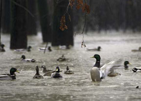 |
Restored wetlands, such as this bottomland hardwood forest near the White River in Arkansas, provide
breeding, nesting, and resting areas for ducks and other waterfowl, wading birds, shorebirds, and other wetlands-dependent wildlife, as well as
opportunities for outdoor recreation and reduced costs to communities for clean water. (FWS) |
To satisfy these requirements, the system must be geospatially enabled with geographic information systems (GIS) technology and it must take advantage of the power of the Internet for promoting collaboration. Such a system could significantly improve the tracking of accomplishments, management of data, dissemination of information, environmental analyses, and decision making. Progress toward the President’s wetlands goal was estimated using the best means available, but this was a challenge because of weaknesses in the reporting system that required an adjustment for overreporting of acreage resulting from partnerships and shared responsibilities. We can significantly improve the reporting system and move forward from estimating accomplishments to measuring them through the use of GIS technology. A proof-of-concept project has been funded by the Environmental Protection Agency (see Tracking and Sharing Wetlands Restoration, Creation, and Improvement Data Using GIS, page 24).
Such a system will allow state and federal agencies and private sector partners to share GIS-based information concerning wetlands using national and international standards-based solutions. Decision makers and managers at all levels inside and outside the government will be able to make better-informed and more timely wetland decisions. We are making progress in linking and publishing data for the public and for partner agencies. The National Wetland Inventory now delivers mapped wetland data for 56 percent of the nation in real time over the Internet to the U.S. Army Corps of Engineers wetland permit tracking system and the FWS Environmental Conservation Online System (ECOS). Almost 44 million users viewed, printed, or downloaded wetlands data through the FWS state-of-the-art Wetlands Mapper with its array of analytical tools. For citizen access, National Wetlands Inventory data are now also viewable through Google Earth. Through expanded use of standards-based web services, FWS is promoting on-demand access to current wetlands information for decision support.
Last year, we correctly estimated that we would achieve wetlands acreage targets of the President’s Earth Day 2004 goal a year earlier than our target date of Earth Day 2009. To ensure that the strides made not only continue, but increase, decision makers and individual citizens should have browser-based access to the information they need to track past accomplishments and make decisions that leverage our limited resources to protect and enhance our nation’s wetlands. As we strive to increase both the quantity and quality of wetlands while facing the challenges of environmental changes, we know the success of this endeavor lies with public–private partnerships and the support of Congress and the American public.
